Earth Observation Data for Environmentally Induced Human Migration
As a widely used but generalised term, "migration" can refer to different human movements with residential intentions. These include geographical differences: internal migration (within the borders of a country), international migration (between countries); conditional differences: voluntary migration, forced migration (including internally displaced persons - IDPs); temporal differences: short-term migration, long-term migration; differences in registered reasons: economic migration, family migration, educational migration. The role of drivers in the evolution of migratory trajectories is still understudied, especially in concerns their interlinked anatomy. Environmental factors, not marginally, but through other push factors such as economic deprivation, are found to have an impact on migratory movements. Climate change has exacerbated this relationship through its effect on the environment and living conditions. In areas with significant environmental degradation (often connected to climate change), forced migration - especially internal displacement and short-term migration to the neighbouring countries (see the case of Somalia, Bangladesh, etc.)- is among the people's strategies for coping with the deprivation of natural resources, health and economic security that environmental deterioration brings about.

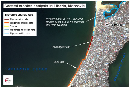
Figure 1. Satellite monitoring of shoreline change rate, derived within ESA’s EO4SD programme (http://eo4sd-climate.gmv.com/)
Migration is thus a multidimensional phenomenon intertwining demographic, economic, social and political features. Environmental and climate-related factors have become the fifth dimension in this list, strongly interlinked with the other four. The degradation of the environment has direct and indirect effects on society, economic conditions, and demography. Also, political conflicts and environmental challenges often concur in the same geography. Consequently, migratory decisions and population movements are being "induced" by environmental degradation to a level that has become a menace to sustainable development and growth. Yet, capturing the impact of environmental/climatic drivers is onerous, especially for slow-onset processes. Emerging approaches based on satellite-based Earth Observation (EO) are, however, paving the way for a better understanding of the environmental drivers of migratory movements.
Satellite EO applications to support migration studies
EO satellites provide systematic, consistent, objective, comparable and cost-effective information of the environment and the anthropogenic/natural processes affecting it. Although the applications of satellite based EO have progressively increased since it began in the 70s (launching of the Landsat mission by NASA), it is only over the last decade that a quantum leap in data availability and variability, together with a ramping computing performance, has led to a revolution in the sector. A central catalyst for this shift was the European program COPERNICUS and its Sentinel satellites (https://www.copernicus.eu/), grouped in seven missions, five of which are currently operative and providing free of cost global data. Sentinel data is not only big data, but also “humongous data''. Only the Sentinel-2 instrument, providing global 10-m resolution images every 5 to 10 days (2-3 days at mid-latitudes), generates annually up to 6 Petabyte of storage (ESA, 2021). These data can be accessed through public big data infrastructures such as the European Space Agency Thematic Exploitation Platforms, the European Commission DIASes and several Open Data Cubes (among others), on private ones like Google Earth Engine, Amazon Web Services, and the Helix nebula Science Hub.
With an unprecedented amount of open-source satellite data, exponential growth of computing performance and powerful AI-based analytics and enhanced predictive capabilities, EO makes it possible to track natural disasters such as floodwaters, wildfires, landslides, and evaluate the intensity and extension of their effects, in a way that was unthinkable 10 years ago. The capability to exploit long time series of satellite data allows us to delve into the past and extract patterns, leading to a better understanding and predictability of the cumulative impact of slow-onset events such as the rise of sea level, droughts, or soil erosion. Similarly, we can monitor from space land degradation processes of anthropic origin, caused by unsustainable use of resources (deforestation, slash and burn agricultural practices etc.).
Satellites are also becoming essential to evaluate the impact of environmental degradation on the livelihood conditions and household economies; for example, through deriving crop productivity reduction estimates after a disaster, or by analyzing road accessibility together with a population grid, to infer population’s access to basic services. In addition, satellites are everyday more widely used to derive proxy indicators of poverty and human well-being using derived variables, such as nighttime light intensity or the extension of urban built-up vs open green areas (examples can be seen in this Compendium of EO contributions, by ESA). Occasionally, satellite information is combined with mobile Call Data Records to gain a close view on the population’s movements during migration crises.
HumMingBird research
HumMingBird is a Horizon 2020 research that aims to improve the mapping and understanding of changing migration flows through a mixed-methods approach that combines qualitative techniques with qualitative techniques, including Big Data analytics and remote sensing. HumMingBird (16 partners and 10 countries) brings together research parties/universities, SMEs, private companies, NGO networks, a European Research Infrastructure Consortium (ERIC). More information can be found in the project website. The research analyses patterns, motivations and new geographies, and tests new methods to forecast emerging and future trends. In the context of Big Data applications for migration studies, HumMingBird uses EO to understand how the successive droughts and floods have affected the migration rates in Somalia, mainly to urban areas. As HumMingBird partner, GMV is analysing radar and optical satellite data from 2016 onwards, in combination with climate data, to derive weekly /monthly assessments of precipitation and soil moisture anomalies, as well as vegetation condition indices which, together with the mapping of floods, is allowing to gain deeper knowledge of the impact these events exerted on crop productivity and this in turn, on displacement rates.
Ethical aspects
The consequences of conflict events and disasters are mostly paid by people living in the area who are forced to migrate or be internally displaced. EO combined with other space technologies (e.g. positioning systems) and AI provide every day more detailed data and information; however the possibilities of numerous uses and the potential for further exploitations pose a risk for these vulnerable people of interest. Although, at the present time, satellite imagery does not allow individual people to be detected - let alone identified, there is a growing awareness on the need of making responsible use of space data, in particular location data (see https://benchmarkinitiative.com/). How space data is used is a matter of ethical behavior, human rights and, mostly, a legal concern. It is crucial to draw attention to the ethical predicaments such as privacy and security concerns, as well as surveillance and (political) power dynamics. It is only then possible to develop strategies and guidelines on how to collect and use geospatial data ethically, especially for migration and humanitarian concepts.

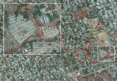
Figure 2. Mogadishu, Somalia, inner city IDP gatherings. GMV interpretation over Google Earth.
Migration is directed to small and disconnected parcels in a larger area where settlements are formed spontaneously.
Discussion and conclusion
Satellite data provide key geospatial insights, on a massive scale and at significantly lower cost than traditional data collection approaches. In particular, these data have demonstrated their potential for investigating the consequences of extreme weather events and slow on-set degrading environmental processes. By allowing close observation of the territory, satellites broaden our perspective on how living conditions and economic activities in a region change as the environment deteriorates. This capability opens the door to strengthen studies on the impact of environmental degradation on migration movements, particularly when satellite data is combined with other space (positioning data) and non-space data (e.g. migration statistics and qualitative data). Consequently, the great potential of EO and remote sensing for migration research is eminent; however, the depth and scope of geospatial data, and in particular positioning data, makes it essential to critically examine its use through an ethical lens, in an open debate on the associated ethical implications.
Authors: Ana Sebastián-López, Tuba Bircan, Rahman Momeni
Exploratorium: Migration Studies

